


1941-1963 HMNZS Tamaki
- Home
- About The Island
- Heritage
- 1941-1963 HMNZS Tamaki
1941-1963 HMNZS Tamaki
“The Rock” Reunion
On 14 February 2020 an event was held on Motuihe to remember all the men who served in the Navy on Motuihe. A large group of veterans (approximately 250) traveled to the island on a vehicular ferry which landed them on Ocean Beach. They took part in a ceremony to unveil two memorial plaques honoring the men who served on the island. The plaques are located at the site of the original flag pole which was at the centre of the navy base. The men affectionately called Motuihe Island “The Rock”.
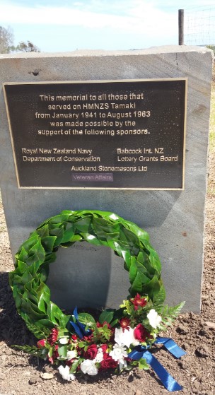
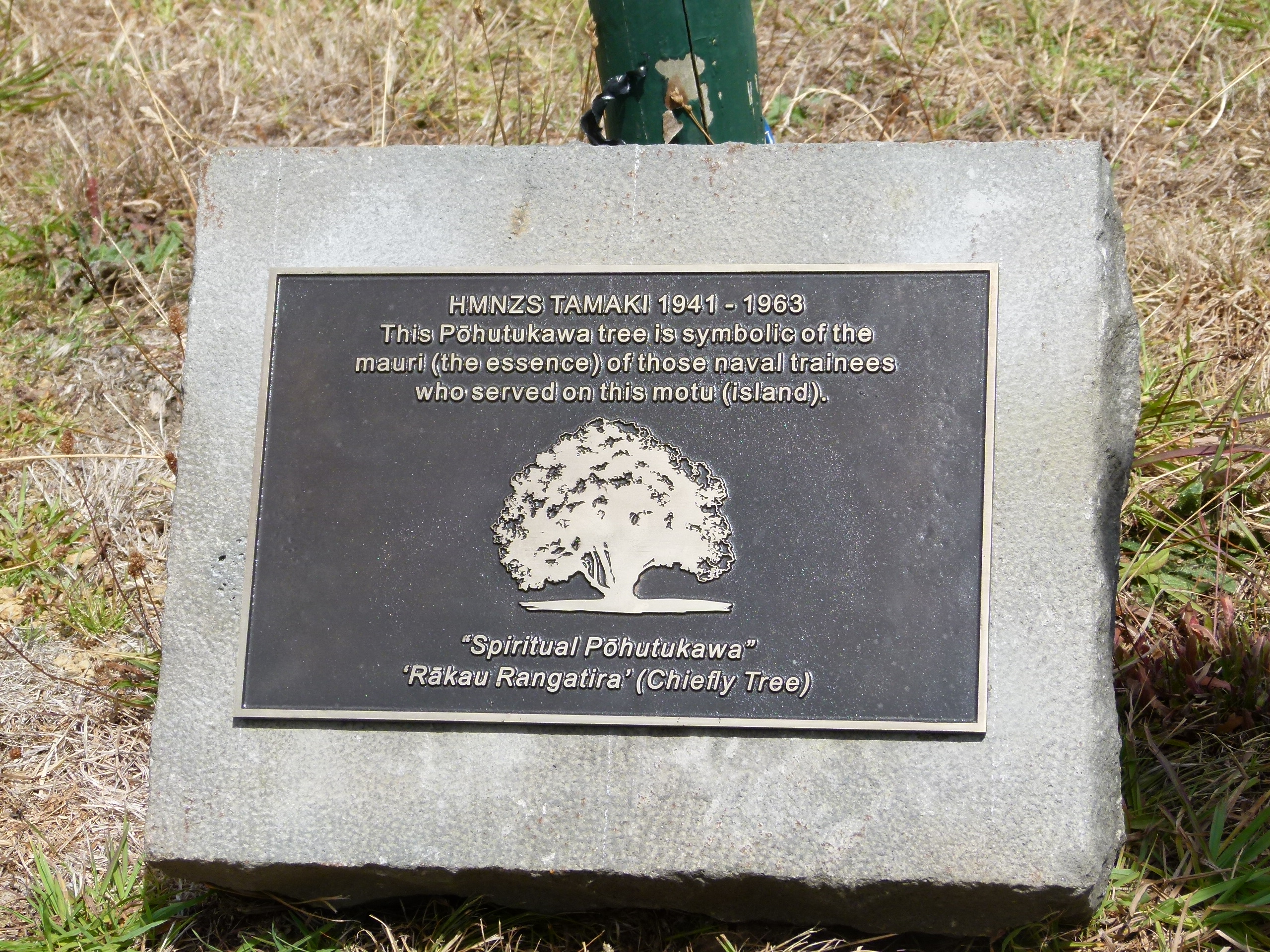
The two plaques commemorating the men who served in the navy on Motuihe. The bottom plaque has a pohutukawa tree in front of it planted as a living memorial. (click photo to enlarge)
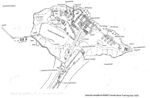
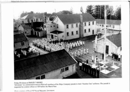
Naval Period 1941-63
With the outbreak of World War II and the urgent need to train more naval personnel, the buildings at the northwest headland on Motuihe were converted into a navy training establishment during 1941, named HMNZS Tamaki.
Motuihe Island was considered an ideal site for a naval training establishment: it was close to Auckland, yet separate from its distractions, provided facilities, and had a beautiful physical setting.
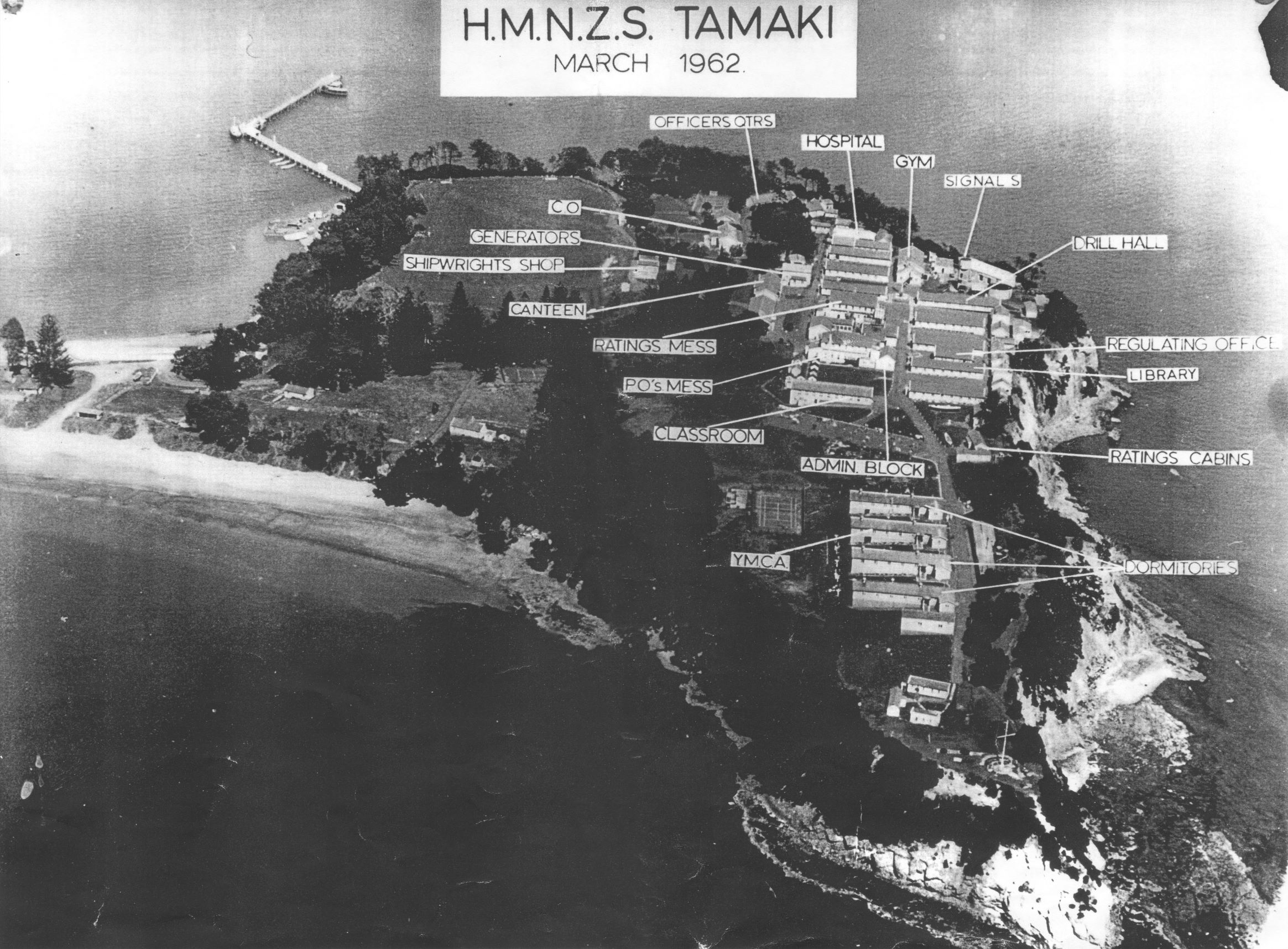
Navy Training base on Motuihe in 1962 (click photo to enlarge)
The twenty-two old quarantine buildings, which could accommodate 287 people, formed the nucleus of the facility. In order to accommodate more naval cadets, between 1941 and 1943, fifteen new buildings with a total floor area of 63,500 square feet were constructed including a provision store, a naval and clothing store, a canteen, a gymnasium and chapel, a school, a signal instruction building, a hospital, a dental clinic, and four large dormitories. Total accommodation was now 517.
Click on diagram to enlarge
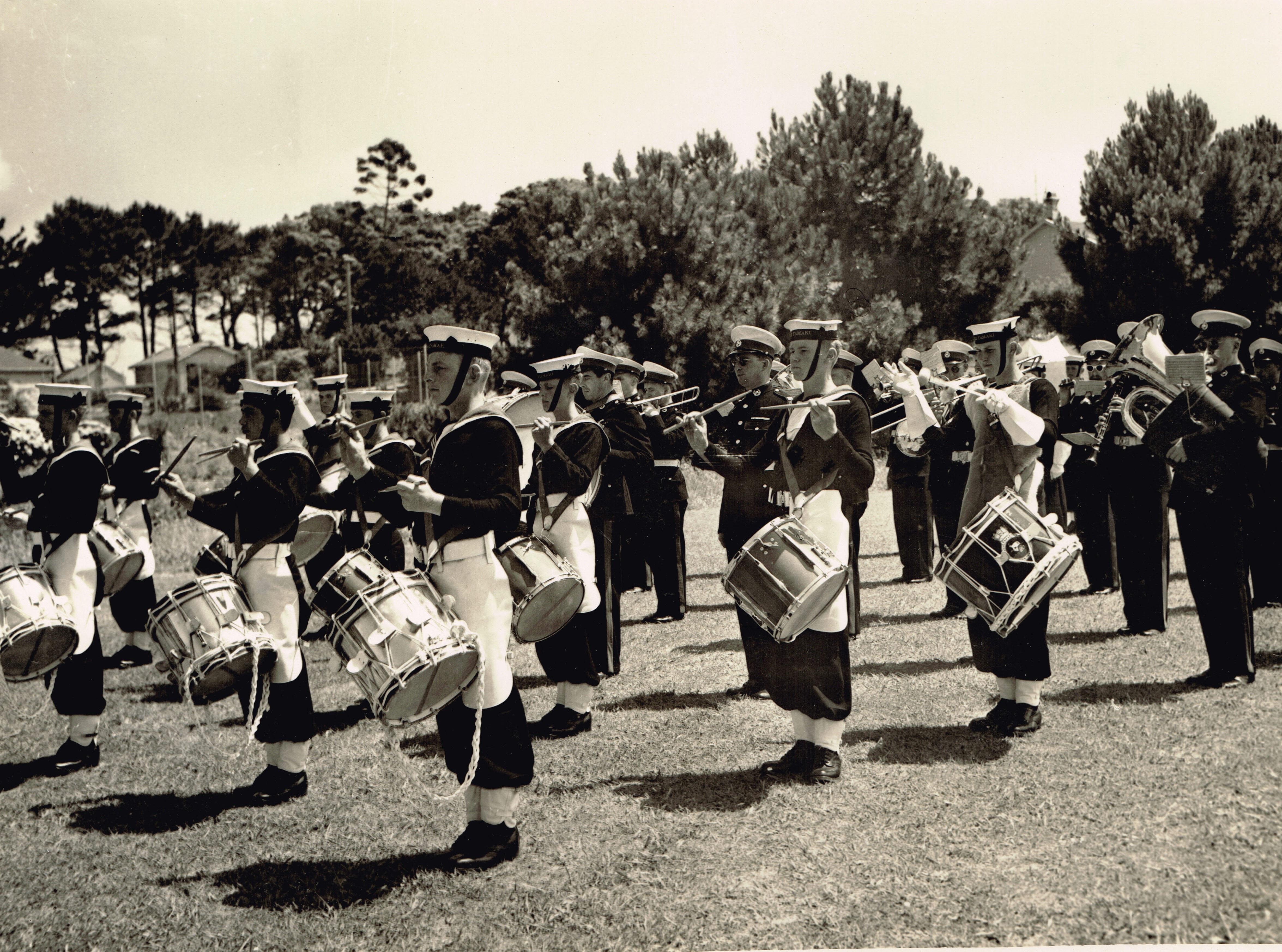
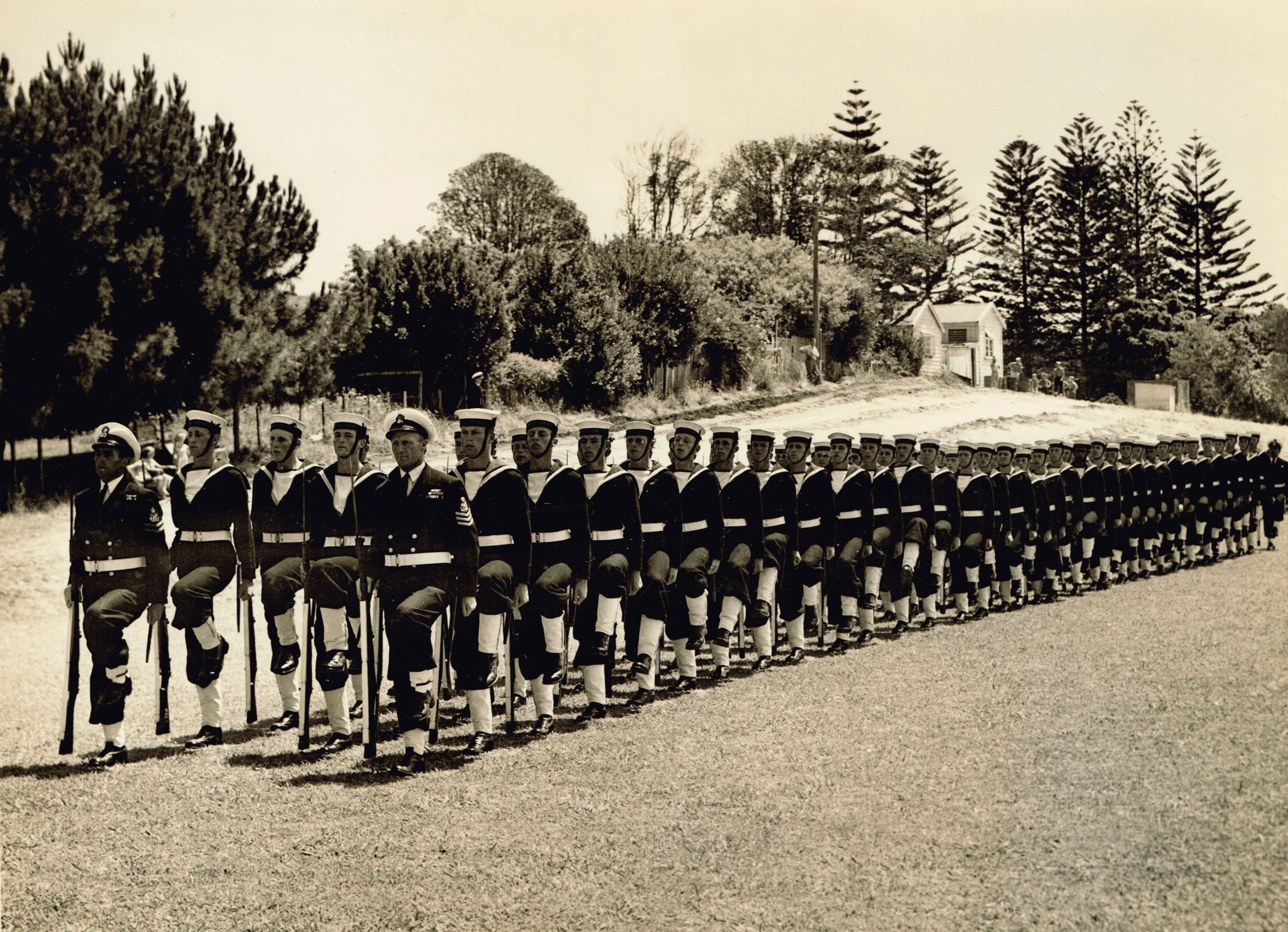
Rehearsing for a parade December 1953 (click on pictures for larger view)
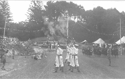
New Year celebrations
More than 6000 recruits passed through Tamaki during the 22 years it operated, including many who served in World War II.
Cadets typically stayed here for their 3 months initial training after entering the navy, during which time they were “broken in” to the navy way of life. Among other things, they sailed Whalers (large open boats), slept in hammocks and sometimes ate their food straight off the table – no plates. The fuel to run the base came from coal which was transported from the wharf using carts that ran on rails – still visible near wharf.
The navy base continued in peacetime to be used for basic training in seamanship, fitness and discipline. In 1963 HMNZS Tamaki moved to the North Shore and the base reverted to Domain Board control.

Jack Donnelly Warrant Officer shares his experience (link)
Des Townson, well know Auckland yacht designer and sailor, was a cadet on Motuihe in 1953. He describes his experience (link)
When the navy vacated in 1963, most of the approximately 70 buildings were demolished. Many were bulldozed over the cliff and remnants of cups and saucers could be found for many years on the rocks below. Some were also moved off the island. Les Chapman, a long time resident of Rakino Island, confirms that the public buildings on the wharf at Rakino came from Motuihe in the 1960s. They have been extensively rebuilt The cost of demolishing the water tower was considered too high so it was left standing. It could now be considered an historic feature, but its future remains in doubt given the danger it poses and the cost of preserving it. The concrete pads near the water tower are the site of the naval flagpole, shown on some of the photos.
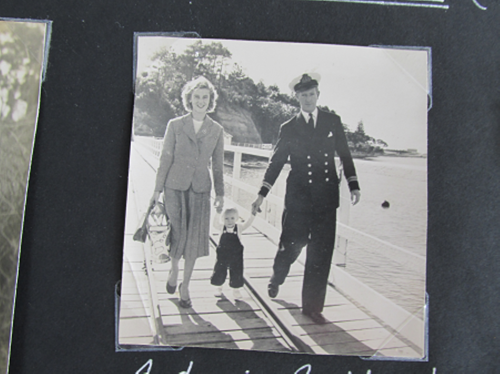
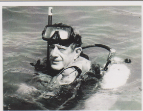
Tony Slark and his wife Eileen on Motuihe Wharf. Tony was the last Naval Surgeon and he and his family lived in the cottage. Tony was the first and only Patron of the Motuihe Trust. He became an expert in preventing the “bends” for divers.
Click here for Interview with Eileen Slark
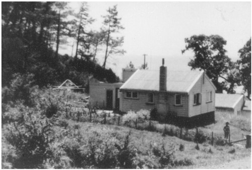
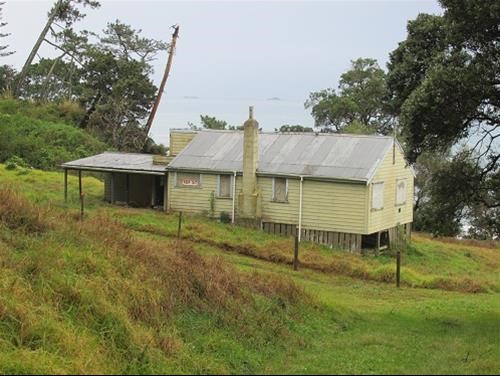
The Naval surgeon’s cottage when in use and now derelict.
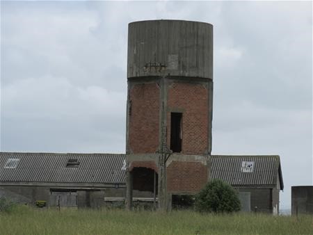
The water tower used to hold salt water for fire fighting now derelict and in a dangerous condition.
Click here for extracts from documents about the Navy moving on to Motuihe
Click here for extracts from documents about Motuihe reopening to the public after WWII
Click here for extracts from documents about the Navy leaving Motuihe
Click here for extracts from documents about the disposal of Navy buildings
Return to Farming 1963-2000
During the navy period the larger portion of the island was farmed and maintained by sheep and fat cattle by farm manager Darryl Cotter on behalf of the Auckland City Council.
1968 – HMNZS Tamaki is gazetted a recreation reserve, and control of Motuihe passes to the Hauraki Gulf Maritime Park Board. The Farm house and Top House date from this period. In 2016 the only buildings remaining from the Navy time are the derelict naval surgeon’s cottage and the water tower which is in a dangerous state.
Motuihe Island (official name: Motuihe Island / Te Motu-a-Ihenga)[1] lies between Motutapu and Waiheke islands in the Hauraki Gulf of New Zealand, near Auckland. The island measures 179 ha (440 acres),[2] of which around 18 ha (44 acres) are remnants of coastal forest. The island is a recreation reserve controlled by the Department of Conservation (DOC) and administered by the Motuihe Trust. It is a popular spot for day trips, accessible from Auckland by seaplane or by private boat. The island is known for its beautiful beaches.[3][4]
The name comes from Te Motu-a-Ihenga, Māori for ‘Ihenga‘s Island’.[5]
Geology
[edit]
Most of the island is formed from Waitemata sandstone overlayed with parnell grit.[6]
History
[edit]
In Tāmaki Māori traditions, the island was known as a location where the Tūrehu, a supernatural people, lived.[6] The island’s name Te Motu-a-Ihenga commemorates Ihenga, an ancestor of the Te Arawa people, who visited the island in the 14th century.[6] The island has extensive archaeological sites, including pā sites, karaka groves and food storage pits. The headland to the east of Ocean Beach, to the north of the island, is the location of Te Rae o Kahu, one of the most visible headland pā in the Hauraki Gulf islands area.[6] Gourds and taro are said to have been commonly grown on the island.[citation needed]
William Fairburn purchased Motuihe in 1839 from William Jowett, Ko Nuki and Te Manago: chiefs of Te Iwi Tutu, Ngāi Tai and Ngatiwaki respectively. They paid one heifer, twenty blankets, ten axes, ten hoes, ten spades, six gowns, two red blankets, 12 Dutch pipes, six iron pots and one shawl.[citation needed]
Very soon after arrival of the Europeans in the area, farming began in the 1840s. Groves of Norfolk pines and olive trees are remnants of this time.[5]
In 1872 the island was designated as a human quarantine station for smallpox victims.[7] A quarantine station was built on the western section of the island in 1873. It was used in 1874 for scarlet fever arriving on an inbound ship and operated for almost 50 years, slowly growing in size.[citation needed]
During the First World War, the station was used as an internment camp whose most famous prisoner was Count Felix von Luckner and his crew of the commerce raider SMS Seeadler.[5] Captured in September 1917, in December Luckner used a Christmas play as a ruse to organise an escape. He got provisions and seized the island’s launch,[8] a scow. Then sailing to the Kermadec Islands he was recaptured (and escaped again),[5] though not before becoming something of an odd type of hero in the eyes of many New Zealanders, for the fact that his numerous and daring wartime escapades had killed only a single person.[citation needed]
Following the First World War, the island was again used as a quarantine station during the 1918 flu pandemic.[citation needed]
With the outbreak of World War II, the buildings became a naval training base, HMNZS Tamaki, and a number of newer buildings were added. The base remained a navy training ground until 1963, when its functions were moved to the North Shore mainland.[5]
Conservation
[edit]

The island’s trust organises an active programme of pest eradication and is gradually replanting sections of the island with native trees. Rats and mice were eradicated in 1996 and rabbits in 2004.[9] The conservation programme has reintroduced native species such as the North Island saddleback (tieke).[10] The Trust maintains a small conservation presence on the island, and usually has a number of volunteers working at the local tree nursery or in other conservation programmes.[citation needed]
In early 2008, rat footprints were found in a tracking tunnel (a device to check for the presence of certain animals) on the island. This set off a substantial effort by the trust and DOC to catch the rodent, which was feared to be part of a larger infestation. The Norwegian rat was eventually trapped by a special hunting dog, allowing plans to release native red-fronted parakeets (kākāriki) to continue as planned[9] in May 2008, when 31 were brought by helicopter from Little Barrier Island, where there is a relatively large population.[11]
In March 2009, fifteen little spotted kiwi were released on the island.[12]
In May 2009, 350 ‘agents’ of The Nikolai Organisation planted 22,400 native trees on Motuihe Island in just one day, which was 40% of the 2009 planting programme.[13][14][15] In 2017, Ricoh New Zealand employees and customers reached their goal of planting 20,000 trees across “Ricoh Valley”.[citation needed]
Many invasive weed species are present on Motuihe. Moth plant (Araujia sericifera), woolly nightshade (Solanum mauritianum) and Italian buckthorn (Rhamnus alaternus) slow the forest’s regeneration and require constant management with the help of volunteers.[citation needed]
from WordPress
via IFTTT
No comments:
Post a Comment